Features on Asian Art, Culture, History & Travel

Features
Features > Doi Chiang Dao
Doi Chiang Dao
Mysterious And Majestic Mountain of Northern Thailand
SEE RELATED IMAGES @ PICTURES FROM HISTORY
"The peak of Chieng Dao stands boldly up, 7,160 feet above sea level. It is a very imposing limestone rock, as it springs almost perpendicularly from the plain to a height of six thousand feet." James Macarthy's description of this eastern outpost of the Upper Tennasserim range, written a hundred years ago, was the first scientific estimation of the height of one of Northern Thailand's most spectacular formations. Working as a surveyor seconded to the Siamese government from the Government of India survey, Macarthy's estimation of the elevation of Chiang Dao Mountain was pleasingly accurate. A modern air chart spots the mountain at 7350 feet.
Though only the third highest peak in Thailand, the others have none of the heavenly thrust of Doi Chiang Dao. The very name, Chiang Dao, means abode of the stars. At first sight of the mountain, a seasoned traveller might well relegate the waterfalls, orchid farms and elephant rides proffered on the 70 kilometre journey north from Chiang Mai to the back of the mind, though he could hardly agree with Macarthy when he wrote “the road is not particularly interesting until we reach Chieng Dao.”
Arriving at the town a few kilometres from the foot of the precipitous slopes of Chiang Dao Mountain, a visitor finds just a single high street bounded on both sides by traditional wooden shops. Though no longer an “irregularly shaped village with a rickety palisade around it” as Macarthy described it, the town retains a certain charm for it has largely escaped the blight of uniform concrete shop houses that dominate many modern towns.
The normality of this small market town belies a dark past, however. The original inhabitants were known as 'Pi Bawk' or spirit people. These people were held to be the unfortunate victims of malign spirits who fed on the hearts or livers making them ill. The spirits were thought to possess healthy people and then to make depredations on neighbours making them ill. A delirious patient would be plied with questions to find the person possessing the spirit. A relative or any one else mentioned would immediately be driven from the village and have to seek shelter in one of the numerous settlements of 'Pi Bawk'. The patient would also be encouraged to follow.
In the hands of cunning administrators, the superstitions of the local people were manipulated to ensure efficient dispatch of adversaries and to populate remote places by force. The modern inhabitants of Chiang Dao, however, would no doubt take offence if their District Officer were to recite a prayer to keep him from the influence of the spirits before any official intercourse with the people. Yet this was how a 'minor prince from Chiang Mai' set about his ministrations in Chiang Dao in Macarthy's time just a century ago.
Even though satellite dishes now adorn the roofs of buildings, the merchants in the town as well as the brightly dressed hill folk who may be seen buying necessities in the market are unlikely to casually discuss the spirits, for animism and superstition still influence the ways of local people.
These ancient beliefs have over the centuries blended with Buddhist traditions. The Tamnan Ang Salung, one of several centuries old local Buddhist chronicles written on palm leaf, advised a visitor as to appropriate behaviour upon visiting the famous caves five kilometres away at the foot of Chiang Dao mountain.
Before entering the caves, according to the tamnan, one was to first bathe and then take precepts before making offerings of flowers, puffed rice, three hundred each of gold and silver candles, four flowering plants, eight flags in each of three colours- black, red, yellow, and white - and one thousand small clay lamps. The chronicle advised that one who went into the cave to make these offerings to the Buddha and to practice meditation would be blessed with good fortune.
Apparently this good fortune included great reward from the ruler of the yakshas, Chao Luang Kham Daeng, and his ten thousand attendants that guarded the cave. This reward included being allowed to leave the caves again for mysterious forces detained those who behaved with impropriety.
Scholars suggest that the tamnan, which were used as texts for sermons and ceremonies in temples, were perhaps not meant to be taken literally as they attribute a spiritual significance to the mountain that strains modern credibility. In practical terms it may well have been wise in former times to enter the labyrinthine caves with sixteen hundred lights to ward off darkness. But nowadays the visitor need only make a small offering for electricity at the entrance to the caves.
Those with a taste for speleology who hire a local guide with a lantern may explore further than the illuminated sections. Yet legend persists. People are reported to have heard the howl of a huge dog which heralds the ghost of a hermit who passed away in the caves a thousand years before.
If the eerie cool is not conducive to peace of mind, the traveller may exit and continue along the paved road that skirts the foot of the mountain's ramparts until it terminates at Wat Pa Bong, an active meditation centre nestling against the cliffs towering above. This journey will also be necessary for one inspired by the limestone towers of the mountain to seek its summit.
Since 1978 Chiang Dao Mountain has been a wildlife sanctuary under the control of the Royal Forestry Department. Permission to enter must be sought from the sanctuary headquarters located next to Wat Pa Bong. According to Prayuth Sithidisairaks, the director of the sanctuary, permission is usually granted for small parties of visitors as long as the purpose of the visit accords with the aims of the sanctuary. In other words a visitor should only shoot the wildlife with a camera, leave no rubbish, restrict camp fires and not take plants home for souvenirs.
Armed with the appropriate Thai documents officially giving permission to ascend to the top, you are then left to contemplate just how to go about it. Smittinand in his 1966 paper entitled 'The Vegetation of Doi Chiang Dao' describes the ascent from the front of the mountain that faces east as 'enterprising'. Looking up from the village near the caves at the base of the mountain this might appear to be an understatement.
For botanists the route affords a clear view of the variety of vegetation at different elevations. For the villagers hired by hikers to carry supplies to the top, it is the fastest route. The rigorous climb itself may be completed by the fit in around five hours, but the hiker should be prepared for frequent slips on the moist track and for occasional scrambling up steep sections of the path.
Most of the Thai visitors who come to the mountain journey up a dirt road that skirts the southern flanks of the U-shaped chain of peaks that form the Chiang Dao massif. To drive past the checkpoint at San Pa Kia and fork from the road up a steep and deteriorated five kilometre track into the sanctuary proper requires the pass from the sanctuary HQ, a signature in the checkpoint logbook and a four-wheel drive vehicle.
The track ends at a forestry sub-station from where a footpath gradually ascends through a hanging valley that forms the west facing open end of the U. The path ends at the summit of Doi Luang, as the highest peak is called.
This valley used to be a favoured area for opium cultivation for the soils at the base of limestone cliffs in the region are especially suitable. Nevertheless, not even cash crop substitutes like carrots and potatoes may be grown there now by the hill people who traditionally cultivated the area since long before the sanctuary was first established.
Hill people are no longer allowed to move their villages within the border of the sanctuary. This they would normally do as fields near villages become exhausted from slash and burn agriculture. Nor are they allowed to clear new areas. Gradually they are having to seek alternative means of support as use of land for cultivation within the 521 square kilometres that form the sanctuary is increasingly restricted.
However the sanctuary is still in transition as Director Prayuth admitted. With thirteen hundred families living in 19 villages constituted from the Hmong, Lisu, Karen, Yang, and Muser tribes, Director Prayuth considered it inhumane for these people to be relocated without first finding suitable land for relocation. In modern Thailand, with government policy aiming at slowing if not stopping deforestation altogether, finding suitable land is hard.
Yet comparison to reports by visiting botanists of deforestation at the beginning of the century suggests that forest cover in the sanctuary is once again increasing. Hikers may yet encounter a few hill people who still tender isolated plots of crops in the grassy swards that remain from the swidden agriculture of previous decades. Even this, however, is scheduled to cease as cultivation in the core area of the sanctuary is to be totally phased out within two years.
While the prospect for flora is upbeat, that for wildlife remains less favourable. Although hunting is banned, at lower levels gunshots may occasionally be heard as local hunters seek meat for the pot. Animals released from captivity into the sanctuary have not survived according to Director Prayuth, who indicated that as long as man inhabited the sanctuary, the competition between species would be an uneven struggle.
Despite the poaching at lower levels, the mountain offers ornithologists a range for bird-life that includes several rare species. Even for a walker without special interests, the four hour hike up the valley to the summit of Doi Luang offers spectacular views of the surrounding peaks. According to season, flowering plants abound, especially near the summit.
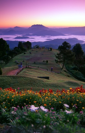
Reaching the top there is no shortage of places to camp, but the visitor must bring water. In the winter months of the cold season, when the views from Doi Luang are amongst the best in Thailand, warm clothing is essential as night temperatures may drop to near freezing point.
In the clear light of the early morning, the view over the clouds formed by inversion covering the valleys raises the spirits. It is as if worldly cares may lay at rest beneath the blanket of mists. The strain of the effort involved in reaching the summit can be forgotten as the majesty of nature unfolds in whatever the eye beholds.
SEE MORE DOI CHIANG DAO IMAGES @ PICTURES FROM HISTORY
Text by Oliver Hargreave; Photos by Oliver Hargreave, David Henley & Pictures From History – © CPA Media